
- California Assembly OKs highest minimum wage in nation
- S. Korea unveils first graphic cigarette warnings
- US joins with South Korea, Japan in bid to deter North Korea
- LPGA golfer Chun In-gee finally back in action
- S. Korea won’t be top seed in final World Cup qualification round
- US men’s soccer misses 2nd straight Olympics
- US back on track in qualifying with 4-0 win over Guatemala
- High-intensity workout injuries spawn cottage industry
- CDC expands range of Zika mosquitoes into parts of Northeast
- Who knew? ‘The Walking Dead’ is helping families connect
California inferno supports predictions for another bad year


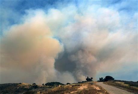
Heavy smoke rises over a hill as a wildfire burns west of Goleta, Calif., Friday, June 17, 2016. The latest size estimate Friday morning is nearly three times the previous acreage, with just 5 percent containment. The fire has been stoked by the region’s afternoon and evening “Sundowner” winds, which blast down the face of the Santa Ynez Mountains toward the Pacific Ocean.
GOLETA, Calif. (AP) — Stoked by winds, a wildfire burning west of Santa Barbara roared down mountain slopes toward the Pacific Ocean, shutting down California’s major coastal highway and forcing a group of firefighters to seek shelter behind a fire engine as flames licked at them.
As the blaze grew to more than 6 square miles, authorities warned Friday that the region’s notorious afternoon and evening “sundowner” gusts would recur through the next two days.
Weekend fire dangers already were expected to worsen with the arrival of an extreme heatwave across the Southwest.
In central New Mexico, a blaze that began Tuesday had destroyed more than two dozen homes and charred more than 26 square miles near the small community of Chilili.
It cast a thick haze over the Manzano Mountain range south of Albuquerque that reached as far north as Denver.
The California inferno appeared to support national wildfire authorities’ predictions of another dangerous and difficult year for the state after years of drought. State firefighters and the U.S. Forest Service already have fought more than 1,800 wildfires since Jan. 1, the California Department of Forestry and Fire Protection said.
While El Nino delivered rain and snow to Northern California this winter, the south was bypassed. What rain fell was just enough to sprout grasses that quickly died, adding to the danger of long-dead vegetation.
“It is ominous and we are concerned because the fuels out there are drought-stressed,” Santa Barbara County Fire Chief Eric Peterson told a press conference.
About 270 homes and ranches were considered at risk in southern Santa Barbara County at the foot of the rugged Santa Ynez Mountains, an east-west trending range that parallels the south-facing coast.
County officials said the fire damaged one building and affected olive, lemon and avocado groves and grazing lands, but no details were released on specific damages.
More than 80 horses were evacuated to a fairground.
Lanny Stableford watched as a fleet of aircraft attacked flames in rugged Refugio Canyon near his ranch, where he keeps 40 head of longhorn cattle.
“I can leave but they won’t let me back so I’m just kind of hanging out here,” he said, noting he was not in danger. “Somebody has to take care of my cows.”
Fires become especially dangerous when sundowners are formed by high pressure inland to the north and low pressure over the ocean to the south, causing gusty winds to sweep down the face of the mountains. A gust in the fire area around 1 a.m. Friday was clocked at 47 mph, the National Weather Service said.
“You can pretty much set your clock by it, about 5 o’clock in the evening the winds start to pick up,” said Eric Boldt, a warning coordination meteorologist.
The Santa Barbara County Fire Department posted a picture of firefighters near El Capitan State Beach taking shelter behind a fire engine as flames and a hail of embers roared toward them.
U.S. 101, the state’s main coastal highway, had to be shut down for hours for the second time since the fire erupted Wednesday.
“I was actually on scene last night and saw some of the fire tornados, and I tell you what, it’s no joke. … It was off the hook,” said Highway Patrol Lt. Steve Larson. He expected more closures.
Sundowners force firefighters to fall back into defensive mode, said Robert Laeng, the federal incident commander.
“Our defensive strategy will continue to emphasize protection of life and property while we look for a place to turn the corner and push this back up into the mountains and get full containment,” he said.
The New Mexico fire was expected to keep moving east and northeast while threatening Chilili, the Tajique area, and the Ponderosa Pine residential area, according to U.S. Forest Service officials.
New Mexico Gov. Susana Martinez took to the air in a National Guard helicopter on Thursday to survey the devastation.
“This is a serious fire,” Martinez said later during a news conference at an Estancia school that holds the command center for the firefighters.
Extremely hot and dry weather was forecast to continue into the weekend, although gusty winds should ease, fire officials said.
In east-central Arizona, progress was made against a 12-square-mile blaze that broke out Wednesday south of Show Low.
“The winds weren’t as bad, and the back-burns did exactly what we wanted them to do,” Navajo County Sheriff KC Clark said at a Thursday afternoon news conference.
However, a small Navajo County community remained evacuated and thousands of other residents were told to be prepared in case they had to leave.
In Nevada, a 300-acre Reno brush fire that threatened dozens of homes was 75 percent contained and crews were mostly in mop-up mode Thursday evening.
Blazes also threatened homes in Utah, where a firefighter hurt his head in a fall.
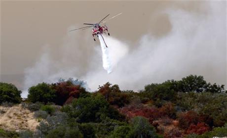
Helicopter drop of the Sherpa Fire in Santa Barbara County, Calif., Friday, June 17, 2016.
One Comment

-
 Special counsel attempts to bring in ex-President Yoon for questioning
A special counsel team investigating former President Yoon Suk...
- July 14, 2025
ENTERTAINMENT
-
 NCT Dream to drop studio album with time-travel concept
Nicknamed a “storytelling powerhouse” for its ability to craft...
- July 14, 2025
-
 BTS’ agency to unveil new boy group next month
BigHit Music, the agency behind global K-pop acts such...
- July 14, 2025

turnip seeds
June 18, 2016 at 6:39 PM
Cream Filling for Cupcakes – Evil Shenanigans