- California Assembly OKs highest minimum wage in nation
- S. Korea unveils first graphic cigarette warnings
- US joins with South Korea, Japan in bid to deter North Korea
- LPGA golfer Chun In-gee finally back in action
- S. Korea won’t be top seed in final World Cup qualification round
- US men’s soccer misses 2nd straight Olympics
- US back on track in qualifying with 4-0 win over Guatemala
- High-intensity workout injuries spawn cottage industry
- CDC expands range of Zika mosquitoes into parts of Northeast
- Who knew? ‘The Walking Dead’ is helping families connect
Daum launches North Korean map service


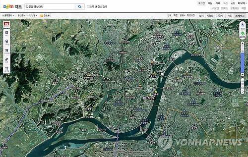
Daum Communications Corp., South Korea’s No. 2 online portal, launches a North Korean map service on Aug. 29, 2014. (Photo courtesy of Daum)
SEOUL (Yonhap) — Daum Communications Corp., South Korea’s No. 2 online portal operator, said Friday it has launched a map service to provide easy public access on the North’s geographic information for the first time in the South.
The map service covers North Korea’s entire territory, and contains its administrative districts and their names, and the locations of mountains, roads, landmark buildings and railroads, said Daum Communications.
Users can access the map through their personal computers, mobile webs and applications, both in satellite and electronic map views, for free, according to the company.
The National Geographic Information Institute made the map on a scale of one to 25,000 and one to 50,000 between 2007 and 2009 and had provided it only to state agencies that deal with North Korean affairs before opening it to the public in March.
“It became far more convenient for people to use North Korea’s geographic data” with the new service, said an NGII official. “It will lead to changes in North Korean research projects by private companies.”
Related Posts


-
 U.S. dispels suspicion of little confidence in S. Korean intel over N.K. troop dispatch to Russia
A State Department spokesperson on Tuesday rejected the notion...
- October 23, 2024
ENTERTAINMENT
-
 ‘Amazon Bullseye,’ an overly familiar comedy
“Amazon Bullseye” is a comedy that tries to blend...
- October 23, 2024
-
 Age can’t stop Cho Yong-pil: K-pop legend’s triumphant return with 20th LP
South Korean music legend Cho Yong-pil proves that age...
- October 23, 2024