- California Assembly OKs highest minimum wage in nation
- S. Korea unveils first graphic cigarette warnings
- US joins with South Korea, Japan in bid to deter North Korea
- LPGA golfer Chun In-gee finally back in action
- S. Korea won’t be top seed in final World Cup qualification round
- US men’s soccer misses 2nd straight Olympics
- US back on track in qualifying with 4-0 win over Guatemala
- High-intensity workout injuries spawn cottage industry
- CDC expands range of Zika mosquitoes into parts of Northeast
- Who knew? ‘The Walking Dead’ is helping families connect
How Pixar recreated 13,000 square miles of US national parks for ‘The Good Dinosaur’


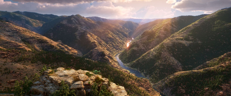
Still from Pixar’s “The Good Dinosaur” (Courtesy of Pixar/Disney)
By Brian Han
What many viewers might not immediately realize about Pixar’s upcoming film “The Good Dinosaur” is that the studio recreated over 13,000 square miles of actual landscape ranging from Wyoming’s Grand Teton National Park to Yellowstone National Park for the film’s set.
Set Supervisor David Munier and his team built a new software specifically for the film that allowed the usage of U.S. Geological Survey (USGS) data to create the virtual world that the film’s main characters, Arlo and Spot, would traverse.
“We would recreate these massive areas that were 110 by 80 kilometers of the Grand Tetons,” Munier said during a private presentation at Pixar headquarters in Emeryville, Calif. “We ended up using data that covered 13,000 square miles of wilderness.”
Pixar’s newest director Peter Sohn along with Producer Denise Ream and other members of the filmmaking team ventured through these same areas on horseback, only to fall in love with what they saw.
“They were ecstatic when they got back, and they wanted to be able to capture that,” he said.
That desire to bring real natural landscapes to an animated film provided a goal. It was up to him to find a way to get there.
“They asked us, ‘How can we have lots of shots like that without having each one be something really special where we have to hand sculpt mountains?’” Munier recalled.
“More specifically, Peter really pushed us to be able to make a film where we could follow his characters with a camera throughout the environments and see off into the distance at all times,” he said.
Usually the backgrounds of vast outdoor establishing shots in animation are painted in after the virtual camera has been assigned to a fixed spot.
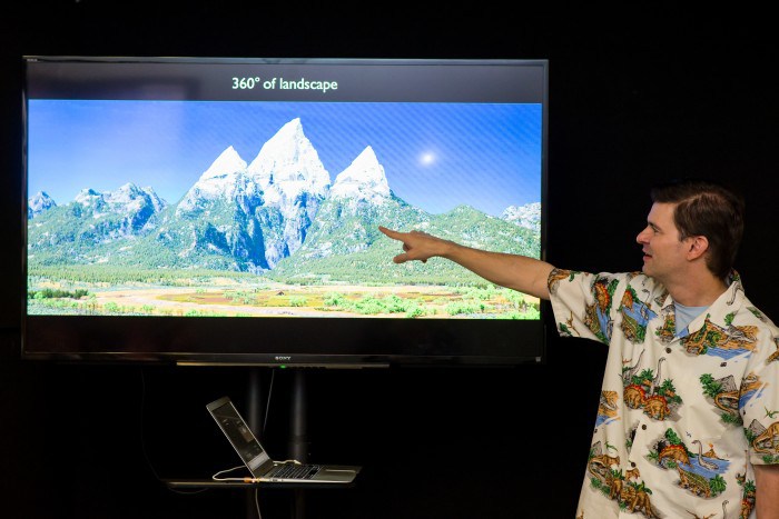
Set Supervisor David Munier for Pixar’s upcoming film “The Good Dinosaur” at Pixar headquarters in Emeryville, Calif. explaining how the studio used U.S. Geological Survey data to create sets for the film. (Courtesy of Pixar/Disney)
Munier admitted that at first the request was “a huge challenge” but after the system was configured it was a matter of dropping in readily available USGS data into the program.
“So what we did is we looked at the U.S. Geological Survey’s website,” he said. “They have lots and lots of satellite data with photos and height data.”
“We downloaded that and stuck a virtual camera into that data and see something similar we would see in a photograph.”
At this point, Sohn was essentially able to navigate around the landscape for miles and miles to find locations and settings for the movie.
Once a location caught his eye, Munier and his team would get to work by filling in the finer details such as “rocks, grass, trees and other environmental details to give Pete a quick way to start filming.”
With almost all of the film taking place out in the open, Sohn thought that a lot of care and time should be put into designing the setting, which resulted in creating miles and miles of usable landscape.
The motivation behind all this came from Sohn’s desire to treat nature as the primary antagonist to Arlo who gets caught in a raging river during a storm that subsequently leaves him far from home.
“I grew up watching films like Black Stallion or Never Cry Wolf and really loved the cinematography of those films,” Sohn said. “This movie takes place outdoors 99.999 percent of the time and we’re one of the few rare movies to do that. I wanted to recreate that feeling.”
The result is a very real and danger-riddled landscape that may even be familiar to some viewers who know the areas well.
-
“The Good Dinosaur” will be in U.S. theaters on Nov. 25, 2015.
Related Posts


One Comment

-
![일본 사도광산 [서경덕 교수 제공. 재판매 및 DB 금지]](http://www.koreatimesus.com/wp-content/uploads/2024/07/PYH2024072610800050400_P4-copy-120x134.jpg) Japan’s Sado mine expected to be listed as UNESCO heritage: Seoul’s foreign ministry
Japan’s Sado mine expected to be listed as UNESCO heritage: Seoul’s foreign ministryJapan’s former gold mine, associated with South Korea’s wartime...
- July 26, 2024
ENTERTAINMENT
-
 2 YouTubers in ‘mukbang’ star blackmail case arrested
A local court on Friday issued arrest warrants for...
- July 26, 2024
-
 Ko Hyun-jung cast in new SBS thriller as serial killer mother
Actress Ko Hyun-jung has been cast in “The Mantis,”...
- July 24, 2024

Pingback: House committee approves measure to open Yellowstone, Grand Teton national … | Recreation Expert